
With over 118 miles of trail just within the city limits, Fayetteville is the perfect place for your bikepacking adventure! The Fayetteville Bikepacking Route Network, created by Bikepacking Roots, is a first-of-its-kind progressive suite of loops with options for beginners and for seasoned pros. Grab the Bikepacking Guide from our visitors center or order one straight to your door.
Bikepacking Route Map
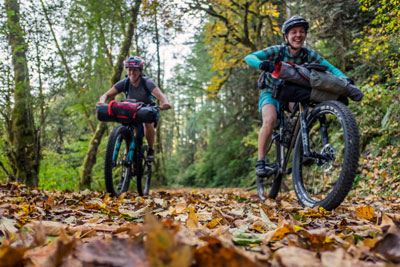
Rides for All Levels
Riders new to adventure cycling can start with a quick overnighter and then progress through these loops to gain experience and confidence. Seasoned bikepackers can find challenge and adventure on the longer rides through the rugged Ozarks, the Boston Mountains, and the Buffalo National River, with scenic overlooks, secluded camping, and fishing and swimming holes along the way.
These routes traverse the traditional lands of the Kiikaapoi (Kickapoo), O-ga-xpa (Quapaw), Očhéthi Šakówiŋ (Sioux), Caddo, and 𐓏𐒰𐓓𐒰𐓓𐒷 𐒼𐓂𐓊𐒻 𐓆𐒻𐒿𐒷 𐓀𐒰^𐓓𐒰^ (Osage).
All routes start in on the downtown square - stop into the Experience Fayetteville visitors center and get a Fayetteville sticker before you roll out!
Lake Wedington Loop
The Lake Wedington Loop is an overnighter taking riders from downtown Fayetteville west to Lake Wedington Recreation Area, through a section of the Ozark National Forest, and on beautiful gravel roads in the rolling oak woodlands above the Illinois River.
Total Distance: 63 miles (or 57 miles)
Elevation Gain: 3,400'

Razorback Greenway Loop
The beginner-bikepacker-friendly Razorback Greenway Loop links the namesake regional paved recreation path with quiet country gravel roads from Fayetteville to Bentonville past numerous parks, restaurants, coffee shops, and singletrack networks.
Total Distance: 78 miles
Elevation Gain: 3,200'

Devil's Den Loop
The Devil’s Den State Park Loop climbs into the Boston Mountains to the scenic gem of a park, home to bikepacking campsites, mountain bike and hiking trails, a swimming pond, cafe, and more - ride this loop as a challenging overnighter or spend an extra day exploring the park.
Total Distance: 73 or 83 miles
Elevation Gain: 4,900' or 5,700'

Boston Mountains Loop
The Boston Mountains Loop is a 145-mile-long gravel tour of the peaks on the skyline south of Fayetteville and takes riders through deep valleys, up long climbs, and along high ridgelines to the scenic summit of White Rock Mountain.
Total Distance: 145 miles
Elevation Gain: 11,600'

Buffalo River Loop
This challenging 187-mile gravel route takes riders into the beautiful and rugged terrain of the Buffalo River region, along the country’s first National River, past the tallest peaks in the state, and through charming small towns along the way.
Total Distance: 187 miles (158 if starting in Goshen; 120 if starting in Huntsville)
Elevation Gain: 16,500' feet (14,600' if starting in Goshen; 11,000' if starting in Huntsville)

Tour de Ozarks Loop
The Tour de Ozarks Loop links together sections of several shorter gravel bikepacking routes into a 190-mile route through the high Boston Mountains and the surrounding scenic farm country and woodlands.
Total Distance: 190 miles
Elevation Gain: 15,200'

Tour de Ozarks Mega Loop
The Tour de Ozarks Mega Loop extends the Tour de Ozarks Loop further east along the Buffalo River Loop to create a 260-mile grand tour of some of the most rugged and scenic country in the Ozarks from steep hollows near Devil’s Den to the highest peaks in Arkansas to the Buffalo National River.
Total Distance: 264 miles
Elevation Gain: 22,500'

Ready to Plan your Bikepacking Trip?
Find more information about the Fayetteville Bikepacking Route Network, including detailed logistical information through Bikepacking Roots. Adventure awaits!
Visit Bikepacking Roots' Website


Disclaimer and copyright
This route and associated information is just a starting point for your preparation, and your safety is your own responsibility. Although this route, its GPS data, and the route guide were prepared after extensive research, their accuracy and reliability are not guaranteed. Check for current conditions, route updates, detours, use common sense, obey local laws and regulations, and travel with alternative means of navigation. Bikepacking Roots and Experience Fayetteville, their directors, employees, and volunteers will in no way be responsible for personal injury or damage to personal property arising in conjunction with following this route or utilizing any of these route resources.
Route guide and resources are copyright and may not be reproduced without written permission from Bikepacking Roots.

